


12:00PM
Map of the day: Ivory Coast's north-south/Muslim-Christian divide
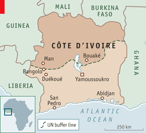 From the Economist.
Described as the UN buffer line, but you know it's the divide between two religions.
It's basically been that way since the middle of the last decade.
 Thomas P.M. Barnett

Reader Comments (1)
Costal ( Christian Sea Trade ) vs Hinterland ( Overland Muslim trade ) .
Not knowing much about Cote D'Ivoire..but the hinterland must have become impoverished due to the fall in value of pack animal trade vs sea trade.
Inevitable coursing of History?